Moià night lights from space
Night Light of Moià (Catalonia) from space (Spain) Src. Average luminocity for 10x10km area is 4.15% and for 50x50km: 17.7955%.
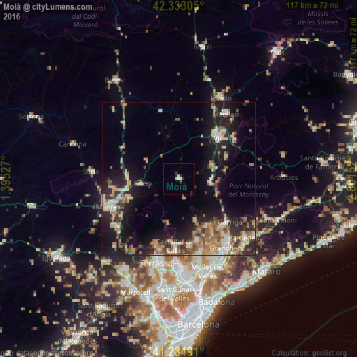
Analysis of Moià night lights 2016
Square area 10x10 km:
 0.15%
0.15%90-99
0.91%80-89
1.06%70-79
0.3%60-69
0%50-59
0%40-49
0.61%30-39
0.61%20-29
2.42%10-19
0%0-9
93.94%Square area 50x50 km:
1.89%90-99
2.73%80-89
2.37%70-79
2.3%60-69
2.77%50-59
2.73%40-49
2.28%30-39
2.45%20-29
5.81%10-19
13.45%0-9
61.24%Clear (daylight) street map image can be seen on geolist.org.
Map coordinates:
42° 19' 59" North, 1° 23' 43" East
41° 48' 40" North, 2° 5' 54.2" East
41° 17' 5.7" North, 2° 48' 5.5" East
Some cities around Moià sort by population:
• Vic
18.5 km =11.5 mi,  44°
44°
• Caldes de Montbui
20.6 km =12.8 mi,  164°
164°
• Bigues i Riells
18.1 km =11.2 mi,  141°
141°
• Sallent
16.9 km =10.5 mi,  275°
275°
• Tona
11.5 km =7.1 mi,  69°
69°
• Centelles
10.1 km =6.3 mi,  98°
98°
• Taradell
17.1 km =10.6 mi, 65°
• Navarcles
17.5 km =10.9 mi,  247°
247°
3115985 (p: 5,086)
Sources (retrieved 2019-11-25):
» Earth at Night: Flat Maps 2012, 2016