Centelles night lights from space
Night Light of Centelles (Catalonia) from space (Spain) Src. Average luminocity for 10x10km area is 17.8815% and for 50x50km: 17.1699%.
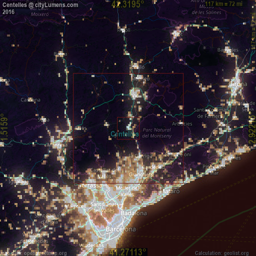
Analysis of Centelles night lights 2016
Square area 10x10 km:
 2.6%
2.6%90-99
1.62%80-89
1.79%70-79
1.79%60-69
2.11%50-59
2.76%40-49
3.73%30-39
2.11%20-29
1.95%10-19
19.48%0-9
60.06%Square area 50x50 km:
1.83%90-99
2.66%80-89
2.25%70-79
2.04%60-69
2.85%50-59
2.91%40-49
2.31%30-39
2.36%20-29
5.79%10-19
12.12%0-9
62.87%Clear (daylight) street map image can be seen on geolist.org.
Map coordinates:
42° 19' 10.2" North, 1° 30' 57.2" East
41° 47' 50.9" North, 2° 13' 8.5" East
41° 16' 16.1" North, 2° 55' 19.7" East
Some cities around Centelles sort by population:
• Vic
15 km =9.3 mi,  11°
11°
• la Garriga
13.8 km =8.6 mi,  157°
157°
• L'Ametlla del Vallès
15.1 km =9.4 mi, 164°
• Bigues i Riells
12.7 km =7.9 mi,  174°
174°
• Tona
5.7 km =3.5 mi, 7°
• Santa Eulàlia de Ronçana
16.4 km =10.2 mi,  175°
175°
• Taradell
10.3 km =6.4 mi,  33°
33°
• Moià
10.1 km =6.3 mi,  278°
278°
3125442 (p: 6,493)
Sources (retrieved 2019-11-25):
» Earth at Night: Flat Maps 2012, 2016