Marchena night lights from space
Night Light of Marchena (Andalusia) from space (Spain) Src. Average luminocity for 10x10km area is 9.3506% and for 50x50km: 3.7168%.
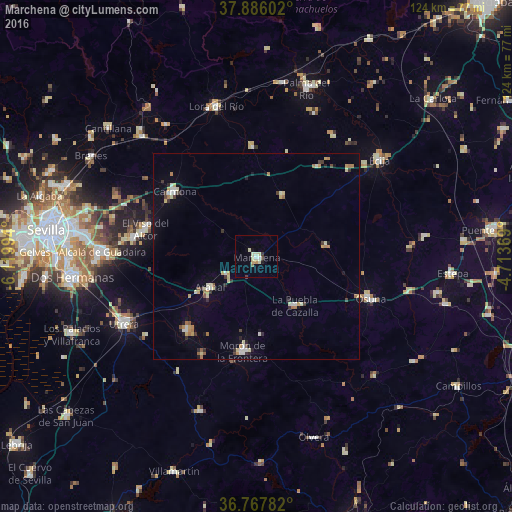
Analysis of Marchena night lights 2016
Square area 10x10 km:
 0.65%
0.65%90-99
2.44%80-89
2.76%70-79
0.65%60-69
0%50-59
0.65%40-49
0.97%30-39
0.65%20-29
0%10-19
1.3%0-9
89.94%Square area 50x50 km:
0.28%90-99
0.57%80-89
0.73%70-79
0.37%60-69
0.56%50-59
0.22%40-49
0.31%30-39
0.48%20-29
0.46%10-19
0.7%0-9
95.32%Clear (daylight) street map image can be seen on geolist.org.
Map coordinates:
37° 53' 9.7" North, 6° 7' 11.8" West
37° 19' 44.4" North, 5° 25' 0.5" West
36° 46' 4.2" North, 4° 42' 49.3" West
Some cities around Marchena sort by population:
• Morón de la Frontera
23.4 km =14.5 mi,  188°
188°
• Carmona
25.7 km =16 mi,  307°
307°
• El Arahal
13.5 km =8.4 mi,  237°
237°
• El Viso del Alcor
27.7 km =17.2 mi,  284°
284°
• La Puebla de Cazalla
15.1 km =9.4 mi,  142°
142°
• Fuentes de Andalucía
16.3 km =10.1 mi,  22°
22°
• Paradas
8.3 km =5.2 mi, 238°
• La Campana
26.7 km =16.6 mi,  358°
358°
2514158 (p: 19,768)
Sources (retrieved 2019-11-25):
» Earth at Night: Flat Maps 2012, 2016