La Puebla de Cazalla night lights from space
Night Light of La Puebla de Cazalla (Andalusia) from space (Spain) Src. Average luminocity for 10x10km area is 5.6361% and for 50x50km: 2.9234%.
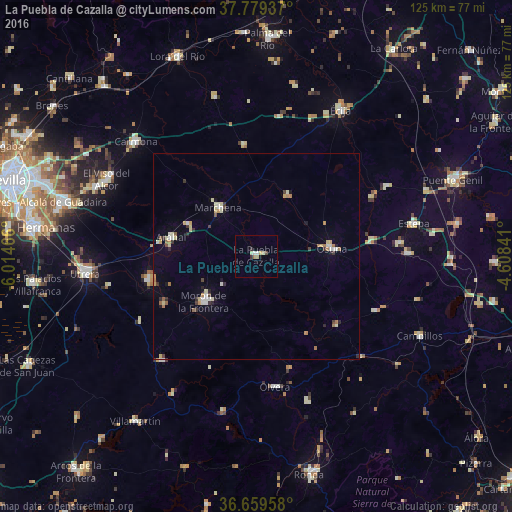
Analysis of La Puebla de Cazalla night lights 2016
Square area 10x10 km:
 0.51%
0.51%90-99
1.87%80-89
0.68%70-79
0.34%60-69
1.19%50-59
0.17%40-49
0%30-39
1.19%20-29
0.85%10-19
0.68%0-9
92.52%Square area 50x50 km:
0.26%90-99
0.48%80-89
0.53%70-79
0.29%60-69
0.48%50-59
0.21%40-49
0.18%30-39
0.44%20-29
0.39%10-19
0.37%0-9
96.37%Clear (daylight) street map image can be seen on geolist.org.
Map coordinates:
37° 46' 45.7" North, 6° 0' 52.8" West
37° 13' 17.6" North, 5° 18' 41.5" West
36° 39' 34.5" North, 4° 36' 30.3" West
Some cities around La Puebla de Cazalla sort by population:
• Morón de la Frontera
16.9 km =10.5 mi,  228°
228°
• Marchena
15.1 km =9.4 mi,  322°
322°
• El Arahal
21.2 km =13.2 mi,  282°
282°
• Osuna
18.5 km =11.5 mi,  84°
84°
• Olvera
32.2 km =20 mi,  172°
172°
• Fuentes de Andalucía
27.1 km =16.8 mi,  353°
353°
• Paradas
18.1 km =11.2 mi,  295°
295°
• El Coronil
32.7 km =20.3 mi,  241°
241°
2515622 (p: 11,325)
Sources (retrieved 2019-11-25):
» Earth at Night: Flat Maps 2012, 2016