El Arahal night lights from space
Night Light of El Arahal (Andalusia) from space (Spain) Src. Average luminocity for 10x10km area is 15.4592% and for 50x50km: 7.1724%.
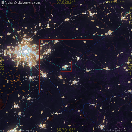
Analysis of El Arahal night lights 2016
Square area 10x10 km:
 0.68%
0.68%90-99
2.38%80-89
5.1%70-79
2.55%60-69
0.51%50-59
1.53%40-49
0.85%30-39
1.7%20-29
1.7%10-19
0.68%0-9
82.31%Square area 50x50 km:
0.62%90-99
0.96%80-89
1.24%70-79
0.55%60-69
1.01%50-59
0.67%40-49
0.82%30-39
1.57%20-29
1.85%10-19
4.51%0-9
86.2%Clear (daylight) street map image can be seen on geolist.org.
Map coordinates:
37° 49' 12.9" North, 6° 14' 54.3" West
37° 15' 45.8" North, 5° 32' 43.1" West
36° 42' 3.8" North, 4° 50' 31.8" West
Some cities around El Arahal sort by population:
• Utrera
22.6 km =14 mi,  247°
247°
• Morón de la Frontera
17.7 km =11 mi,  152°
152°
• Mairena del Alcor
21.8 km =13.5 mi,  304°
304°
• Marchena
13.5 km =8.4 mi,  57°
57°
• El Viso del Alcor
21 km =13 mi,  312°
312°
• La Puebla de Cazalla
21.2 km =13.2 mi,  102°
102°
• Paradas
5.3 km =3.3 mi,  54°
54°
• El Coronil
21.8 km =13.5 mi,  201°
201°
2518729 (p: 19,248)
Sources (retrieved 2019-11-25):
» Earth at Night: Flat Maps 2012, 2016