La Campana night lights from space
Night Light of La Campana (Andalusia) from space (Spain) Src. Average luminocity for 10x10km area is 2.9383% and for 50x50km: 3.7367%.
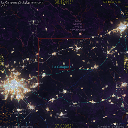
Analysis of La Campana night lights 2016
Square area 10x10 km:
 0.32%
0.32%90-99
0.32%80-89
1.46%70-79
0.49%60-69
0%50-59
0%40-49
0%30-39
0%20-29
0.65%10-19
0%0-9
96.75%Square area 50x50 km:
0.33%90-99
0.48%80-89
0.66%70-79
0.48%60-69
0.48%50-59
0.2%40-49
0.34%30-39
0.6%20-29
0.54%10-19
1.41%0-9
94.47%Clear (daylight) street map image can be seen on geolist.org.
Map coordinates:
38° 7' 26.9" North, 6° 7' 47.4" West
37° 34' 8.1" North, 5° 25' 36.1" West
37° 0' 34.3" North, 4° 43' 24.9" West
Some cities around La Campana sort by population:
• Écija
30.5 km =19 mi,  95°
95°
• Carmona
22.2 km =13.8 mi,  240°
240°
• Palma del Río
19.4 km =12.1 mi,  41°
41°
• Marchena
26.7 km =16.6 mi,  178°
178°
• Lora del Río
13.4 km =8.3 mi,  318°
318°
• Tocina
27.4 km =17 mi,  279°
279°
• Fuentes de Andalucía
13.6 km =8.5 mi,  148°
148°
• Villanueva del Río y Minas
27 km =16.8 mi,  290°
290°
2516118 (p: 5,197)
Sources (retrieved 2019-11-25):
» Earth at Night: Flat Maps 2012, 2016