Paradas night lights from space
Night Light of Paradas (Andalusia) from space (Spain) Src. Average luminocity for 10x10km area is 11.1173% and for 50x50km: 5.4215%.
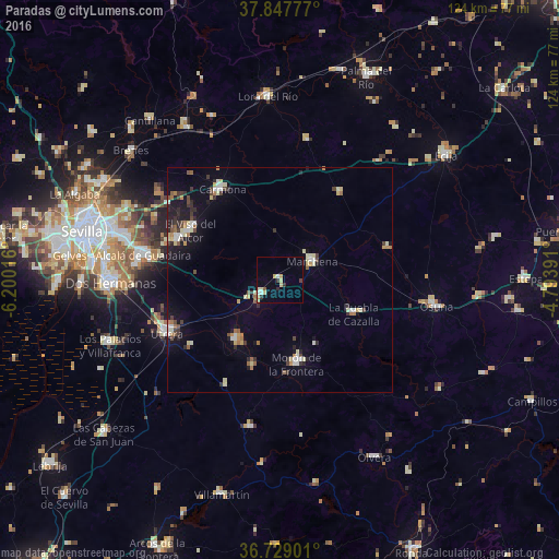
Analysis of Paradas night lights 2016
Square area 10x10 km:
 0.68%
0.68%90-99
1.87%80-89
3.91%70-79
1.19%60-69
0.17%50-59
0.68%40-49
0.51%30-39
1.7%20-29
1.19%10-19
0%0-9
88.1%Square area 50x50 km:
0.5%90-99
0.83%80-89
0.94%70-79
0.36%60-69
0.71%50-59
0.5%40-49
0.59%30-39
0.89%20-29
0.96%10-19
2.85%0-9
90.87%Clear (daylight) street map image can be seen on geolist.org.
Map coordinates:
37° 50' 52" North, 6° 12' 0.6" West
37° 17' 25.7" North, 5° 29' 49.3" West
36° 43' 44.4" North, 4° 47' 38.1" West
Some cities around Paradas sort by population:
• Morón de la Frontera
19.2 km =11.9 mi,  168°
168°
• Carmona
24 km =14.9 mi,  326°
326°
• Mairena del Alcor
24.1 km =15 mi,  292°
292°
• Marchena
8.3 km =5.2 mi,  58°
58°
• El Arahal
5.3 km =3.3 mi,  234°
234°
• El Viso del Alcor
22.7 km =14.1 mi,  299°
299°
• La Puebla de Cazalla
18.1 km =11.2 mi,  115°
115°
• Fuentes de Andalucía
23.5 km =14.6 mi,  34°
34°
2512933 (p: 7,084)
Sources (retrieved 2019-11-25):
» Earth at Night: Flat Maps 2012, 2016