Las Matas night lights from space
Night Light of Las Matas (Madrid) from space (Spain) Src. Average luminocity for 10x10km area is 48.2614% and for 50x50km: 40.2565%.
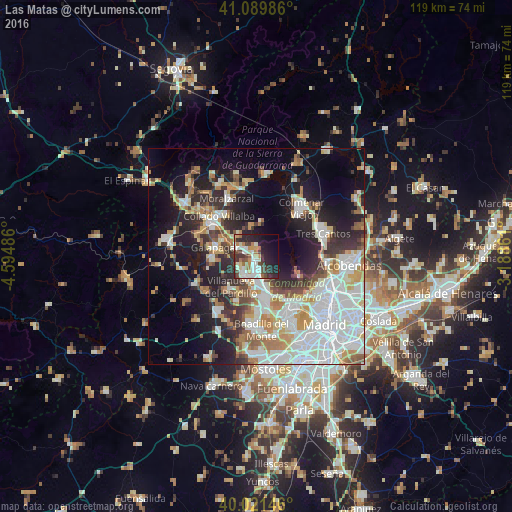
Analysis of Las Matas night lights 2016
Square area 10x10 km:
 8.93%
8.93%90-99
13.15%80-89
3.73%70-79
4.87%60-69
7.31%50-59
3.08%40-49
8.44%30-39
9.25%20-29
15.91%10-19
15.58%0-9
9.74%Square area 50x50 km:
11.38%90-99
9.17%80-89
3.57%70-79
4.93%60-69
4.29%50-59
3.31%40-49
3.5%30-39
4.54%20-29
8.75%10-19
16.13%0-9
30.44%Clear (daylight) street map image can be seen on geolist.org.
Map coordinates:
41° 5' 23.5" North, 4° 35' 41.5" West
40° 33' 28" North, 3° 53' 30.2" West
40° 1' 17.3" North, 3° 11' 19" West
Some cities around Las Matas sort by population:
• Las Rozas de Madrid
7.4 km =4.6 mi,  168°
168°
• Majadahonda
9.5 km =5.9 mi, 169°
• Collado-Villalba
12.8 km =8 mi,  311°
311°
• Galapagar
9.8 km =6.1 mi,  283°
283°
• Torrelodones
3.6 km =2.2 mi, 305°
• Villanueva del Pardillo
9.7 km =6 mi,  219°
219°
• Colmenarejo
10.6 km =6.6 mi,  271°
271°
• Hoyo de Manzanares
7.3 km =4.5 mi,  349°
349°
3118900 (p: 14,213)
Sources (retrieved 2019-11-25):
» Earth at Night: Flat Maps 2012, 2016