la Trinitat Vella night lights from space
Night Light of la Trinitat Vella (Catalonia) from space (Spain) Src. Average luminocity for 10x10km area is 89.2993% and for 50x50km: 45.4441%.
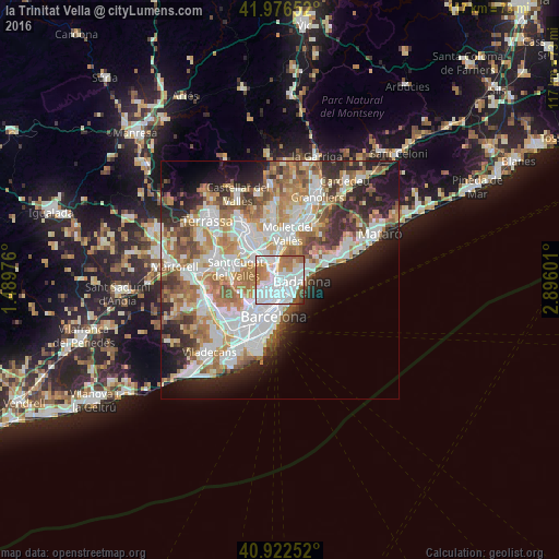
Analysis of la Trinitat Vella night lights 2016
Square area 10x10 km:
 43.71%
90-99
25.51%80-89
3.74%70-79
9.18%60-69
11.22%50-59
5.1%40-49
0.85%30-39
0.68%20-29
0%10-19
0%0-9
0%Square area 50x50 km:
11.65%90-99
10.68%80-89
4.34%70-79
5.49%60-69
8.37%50-59
6.26%40-49
3.86%30-39
4.45%20-29
8.26%10-19
8.77%0-9
27.88%Clear (daylight) street map image can be seen on geolist.org.
Map coordinates:
41° 58' 35.5" North, 1° 29' 23.1" East
41° 27' 6" North, 2° 11' 34.4" East
40° 55' 21.1" North, 2° 53' 45.6" East
Some cities around la Trinitat Vella sort by population:
• Nou Barris
1.7 km =1.1 mi,  229°
229°
• Sant Andreu
1.8 km =1.1 mi,  188°
188°
• Santa Coloma de Gramenet
1.3 km =0.8 mi,  90°
90°
• Barri de Sant Andreu
1.7 km =1.1 mi, 187°
• la Prosperitat
1.3 km =0.8 mi,  222°
222°
• les Roquetes
1.5 km =0.9 mi,  254°
254°
• el Bon Pastor
1.8 km =1.1 mi,  155°
155°
• Verdun
1.7 km =1.1 mi,  235°
235°
11549809 (p: 10,253)
Sources (retrieved 2019-11-25):
» Earth at Night: Flat Maps 2012, 2016