La Pineda night lights from space
Night Light of La Pineda (Catalonia) from space (Spain) Src. Average luminocity for 10x10km area is 55.9075% and for 50x50km: 16.3421%.
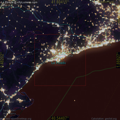
Analysis of La Pineda night lights 2016
Square area 10x10 km:
 18.34%
90-99
16.23%80-89
4.55%70-79
6.66%60-69
3.57%50-59
4.38%40-49
0.16%30-39
3.25%20-29
16.88%10-19
18.34%0-9
7.63%Square area 50x50 km:
2.44%90-99
2.89%80-89
1.82%70-79
2%60-69
1.97%50-59
2.35%40-49
1.29%30-39
2.4%20-29
5.52%10-19
13.87%0-9
63.45%Clear (daylight) street map image can be seen on geolist.org.
Map coordinates:
41° 36' 14.9" North, 0° 28' 55.3" East
41° 4' 34.5" North, 1° 11' 6.5" East
40° 32' 38.7" North, 1° 53' 17.8" East
Some cities around La Pineda sort by population:
• Tarragona
7.1 km =4.4 mi,  50°
50°
• Reus
11 km =6.8 mi,  323°
323°
• Cambrils
10.6 km =6.6 mi,  266°
266°
• Salou
3.6 km =2.2 mi, 270°
• Vila-seca
5 km =3.1 mi, 321°
• La Canonja
5 km =3.1 mi,  355°
355°
• Riudoms
13 km =8.1 mi,  299°
299°
• Constantí
8.9 km =5.5 mi,  14°
14°
3119231 (p: 17,305)
Sources (retrieved 2019-11-25):
» Earth at Night: Flat Maps 2012, 2016