Riudoms night lights from space
Night Light of Riudoms (Catalonia) from space (Spain) Src. Average luminocity for 10x10km area is 36.5016% and for 50x50km: 15.1633%.
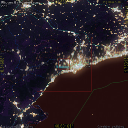
Analysis of Riudoms night lights 2016
Square area 10x10 km:
 4.22%
4.22%90-99
5.52%80-89
6.01%70-79
4.87%60-69
2.76%50-59
3.9%40-49
2.27%30-39
10.06%20-29
17.53%10-19
38.47%0-9
4.38%Square area 50x50 km:
2.27%90-99
2.66%80-89
1.7%70-79
1.76%60-69
1.86%50-59
2.24%40-49
1.23%30-39
2.35%20-29
4.77%10-19
11.82%0-9
67.33%Clear (daylight) street map image can be seen on geolist.org.
Map coordinates:
41° 39' 38.8" North, 0° 20' 48.8" East
41° 7' 60" North, 1° 3' 0" East
40° 36' 5.8" North, 1° 45' 11.3" East
Some cities around Riudoms sort by population:
• Reus
5.4 km =3.4 mi,  61°
61°
• Cambrils
7.1 km =4.4 mi,  173°
173°
• Salou
9.9 km =6.2 mi,  129°
129°
• Vila-seca
8.5 km =5.3 mi,  106°
106°
• La Pineda
13 km =8.1 mi,  119°
119°
• Mont-roig del Camp
9.2 km =5.7 mi,  235°
235°
• La Canonja
11 km =6.8 mi,  97°
97°
• Constantí
13.8 km =8.6 mi,  80°
80°
3111590 (p: 5,679)
Sources (retrieved 2019-11-25):
» Earth at Night: Flat Maps 2012, 2016