Cambrils night lights from space
Night Light of Cambrils (Catalonia) from space (Spain) Src. Average luminocity for 10x10km area is 33.6542% and for 50x50km: 14.7631%.
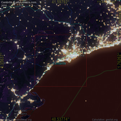

Analysis of Cambrils night lights 2016
Square area 10x10 km:
 5.52%
5.52%90-99
4.38%80-89
5.03%70-79
1.95%60-69
3.57%50-59
3.57%40-49
3.08%30-39
9.58%20-29
14.94%10-19
35.88%0-9
12.5%Square area 50x50 km:
2.24%90-99
2.55%80-89
1.67%70-79
1.77%60-69
1.82%50-59
2.22%40-49
1.23%30-39
2.31%20-29
4.83%10-19
10.98%0-9
68.38%Clear (daylight) street map image can be seen on geolist.org.
Map coordinates:
41° 35' 52.5" North, 0° 21' 22.9" East
41° 4' 11.9" North, 1° 3' 34.2" East
40° 32' 15.9" North, 1° 45' 45.4" East
Some cities around Cambrils sort by population:
• Reus
10.4 km =6.5 mi,  22°
22°
• Salou
6.9 km =4.3 mi,  83°
83°
• Vila-seca
8.7 km =5.4 mi,  58°
58°
• La Pineda
10.6 km =6.6 mi,  86°
86°
• Mont-roig del Camp
8.6 km =5.3 mi,  282°
282°
• La Canonja
11.6 km =7.2 mi, 60°
• Riudoms
7.1 km =4.4 mi,  353°
353°
• Constantí
15.9 km =9.9 mi,  53°
53°
3126888 (p: 32,422)
Sources (retrieved 2019-11-25):
» Earth at Night: Flat Maps 2012, 2016