La Almunia de Doña Godina night lights from space
Night Light of La Almunia de Doña Godina (Aragon) from space (Spain) Src. Average luminocity for 10x10km area is 11.7653% and for 50x50km: 3.3025%.
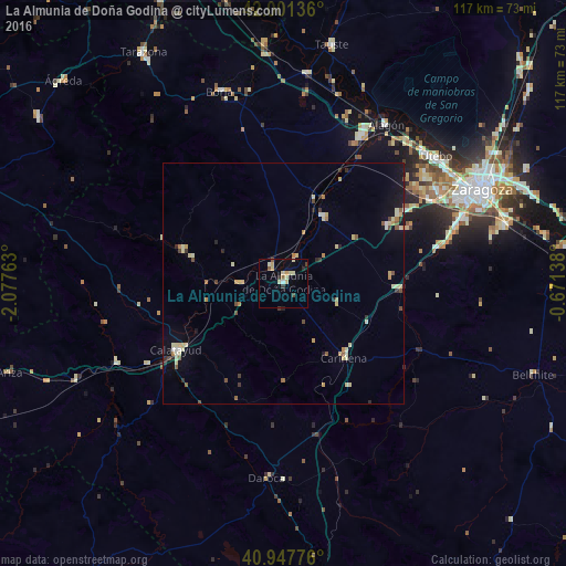
Analysis of La Almunia de Doña Godina night lights 2016
Square area 10x10 km:
 0.34%
0.34%90-99
1.7%80-89
5.1%70-79
0.68%60-69
0.17%50-59
1.53%40-49
0.85%30-39
1.02%20-29
1.19%10-19
0.68%0-9
86.73%Square area 50x50 km:
0.12%90-99
0.43%80-89
0.95%70-79
0.33%60-69
0.36%50-59
0.4%40-49
0.39%30-39
0.31%20-29
0.46%10-19
1.03%0-9
95.21%Clear (daylight) street map image can be seen on geolist.org.
Map coordinates:
42° 0' 4.9" North, 2° 4' 39.5" West
41° 28' 36.1" North, 1° 22' 28.2" West
40° 56' 51.9" North, 0° 40' 17" West
Some cities around La Almunia de Doña Godina sort by population:
• Zaragoza
45.9 km =28.5 mi,  64°
64°
• Delicias
43.3 km =26.9 mi, 63°
• Oliver-Valdefierro
41.2 km =25.6 mi, 63°
• Almozara
44.4 km =27.6 mi, 62°
• Calatayud
26.3 km =16.3 mi,  238°
238°
• Montecanal
40.1 km =24.9 mi, 64°
• Utebo
40.5 km =25.2 mi,  50°
50°
• Alagón
38.9 km =24.2 mi,  33°
33°
3120012 (p: 6,646)
Sources (retrieved 2019-11-25):
» Earth at Night: Flat Maps 2012, 2016