Calamonte night lights from space
Night Light of Calamonte (Extremadura) from space (Spain) Src. Average luminocity for 10x10km area is 27.1735% and for 50x50km: 4.3712%.
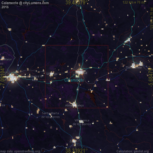
Analysis of Calamonte night lights 2016
Square area 10x10 km:
 7.14%
7.14%90-99
6.97%80-89
1.36%70-79
2.89%60-69
3.91%50-59
0.85%40-49
0.68%30-39
1.53%20-29
3.4%10-19
23.64%0-9
47.62%Square area 50x50 km:
0.53%90-99
0.64%80-89
0.75%70-79
0.71%60-69
0.41%50-59
0.25%40-49
0.43%30-39
0.47%20-29
0.55%10-19
3.17%0-9
92.1%Clear (daylight) street map image can be seen on geolist.org.
Map coordinates:
39° 26' 1.6" North, 7° 5' 27.7" West
38° 53' 19" North, 6° 23' 16.5" West
38° 20' 21.2" North, 5° 41' 5.2" West
Some cities around Calamonte sort by population:
• Mérida
4.9 km =3 mi,  51°
51°
• Almendralejo
22.9 km =14.2 mi,  184°
184°
• Montijo
20 km =12.4 mi,  276°
276°
• Villafranca de los Barros
36.6 km =22.7 mi,  173°
173°
• Guareña
25.1 km =15.6 mi,  97°
97°
• Puebla de la Calzada
20.6 km =12.8 mi,  271°
271°
• Aceuchal
28.3 km =17.6 mi,  197°
197°
• Talavera La Real
33 km =20.5 mi, 267°
2520568 (p: 6,117)
Sources (retrieved 2019-11-25):
» Earth at Night: Flat Maps 2012, 2016