Gójar night lights from space
Night Light of Gójar (Andalusia) from space (Spain) Src. Average luminocity for 10x10km area is 54.3469% and for 50x50km: 12.2934%.
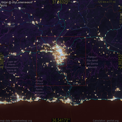
Analysis of Gójar night lights 2016
Square area 10x10 km:
 5.95%
5.95%90-99
12.24%80-89
7.65%70-79
9.69%60-69
16.67%50-59
6.46%40-49
3.06%30-39
3.91%20-29
14.63%10-19
15.48%0-9
4.25%Square area 50x50 km:
1.23%90-99
2.12%80-89
1.61%70-79
1.7%60-69
2.79%50-59
1.62%40-49
1.33%30-39
1.41%20-29
3.49%10-19
6.83%0-9
75.87%Clear (daylight) street map image can be seen on geolist.org.
Map coordinates:
37° 39' 47.7" North, 4° 18' 31.6" West
37° 6' 16.4" North, 3° 36' 20.3" West
36° 32' 30.2" North, 2° 54' 9.1" West
Some cities around Gójar sort by population:
• Armilla
4.7 km =2.9 mi,  338°
338°
• Zubia
2.5 km =1.6 mi,  49°
49°
• Las Gabias
6.7 km =4.2 mi,  300°
300°
• Ogíjares
1.6 km =1 mi,  353°
353°
• Churriana de la Vega
5.8 km =3.6 mi,  321°
321°
• Huétor Vega
5.5 km =3.4 mi,  35°
35°
• Monachil
6.9 km =4.3 mi,  62°
62°
• Otura
3 km =1.9 mi,  233°
233°
2517197 (p: 5,024)
Sources (retrieved 2019-11-25):
» Earth at Night: Flat Maps 2012, 2016