Huétor Vega night lights from space
Night Light of Huétor Vega (Andalusia) from space (Spain) Src. Average luminocity for 10x10km area is 60.0714% and for 50x50km: 12.2574%.
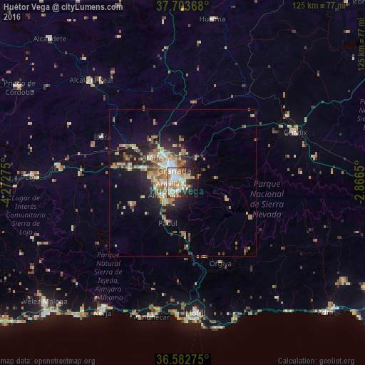
Analysis of Huétor Vega night lights 2016
Square area 10x10 km:
 12.76%
90-99
16.67%80-89
10.2%70-79
8.33%60-69
10.71%50-59
2.38%40-49
3.57%30-39
5.1%20-29
9.52%10-19
15.99%0-9
4.76%Square area 50x50 km:
1.23%90-99
2.06%80-89
1.59%70-79
1.76%60-69
2.9%50-59
1.58%40-49
1.29%30-39
1.42%20-29
3.43%10-19
6.79%0-9
75.96%Clear (daylight) street map image can be seen on geolist.org.
Map coordinates:
37° 42' 13.2" North, 4° 16' 21.9" West
37° 8' 43" North, 3° 34' 10.7" West
36° 34' 57.9" North, 2° 51' 59.4" West
Some cities around Huétor Vega sort by population:
• Granada
5.8 km =3.6 mi,  325°
325°
• Armilla
4.9 km =3 mi,  268°
268°
• Zubia
3.2 km =2 mi,  203°
203°
• Ogíjares
4.5 km =2.8 mi,  229°
229°
• Churriana de la Vega
6.8 km =4.2 mi, 269°
• Cenes de la Vega
3.4 km =2.1 mi,  61°
61°
• Monachil
3.2 km =2 mi,  115°
115°
• Gójar
5.5 km =3.4 mi,  215°
215°
2516498 (p: 11,324)
Sources (retrieved 2019-11-25):
» Earth at Night: Flat Maps 2012, 2016