Las Gabias night lights from space
Night Light of Las Gabias (Andalusia) from space (Spain) Src. Average luminocity for 10x10km area is 53.2041% and for 50x50km: 12.3569%.
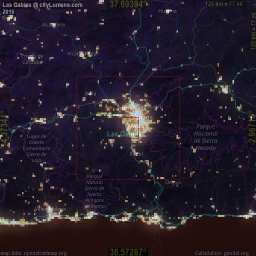
Analysis of Las Gabias night lights 2016
Square area 10x10 km:
 4.25%
4.25%90-99
12.24%80-89
8.5%70-79
13.1%60-69
13.27%50-59
7.65%40-49
2.55%30-39
1.19%20-29
14.63%10-19
17.69%0-9
4.93%Square area 50x50 km:
1.23%90-99
2.12%80-89
1.62%70-79
1.71%60-69
2.73%50-59
1.7%40-49
1.31%30-39
1.48%20-29
3.46%10-19
6.82%0-9
75.82%Clear (daylight) street map image can be seen on geolist.org.
Map coordinates:
37° 41' 38.2" North, 4° 22' 24.3" West
37° 8' 7.7" North, 3° 40' 13" West
36° 34' 22.3" North, 2° 58' 1.8" West
Some cities around Las Gabias sort by population:
• Armilla
4.1 km =2.5 mi,  76°
76°
• Zubia
7.9 km =4.9 mi,  103°
103°
• Santafé
7.3 km =4.5 mi,  323°
323°
• Ogíjares
5.8 km =3.6 mi,  108°
108°
• Churriana de la Vega
2.4 km =1.5 mi,  63°
63°
• Cúllar-Vega
2 km =1.2 mi,  358°
358°
• Otura
6.2 km =3.9 mi,  147°
147°
• Gójar
6.7 km =4.2 mi,  120°
120°
6559641 (p: 16,369)
Sources (retrieved 2019-11-25):
» Earth at Night: Flat Maps 2012, 2016