Monachil night lights from space
Night Light of Monachil (Andalusia) from space (Spain) Src. Average luminocity for 10x10km area is 37.2687% and for 50x50km: 12.0923%.
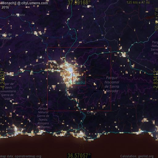
Analysis of Monachil night lights 2016
Square area 10x10 km:
 4.59%
4.59%90-99
8.16%80-89
7.99%70-79
5.27%60-69
7.31%50-59
1.7%40-49
2.04%30-39
4.93%20-29
10.03%10-19
16.84%0-9
31.12%Square area 50x50 km:
1.23%90-99
2.09%80-89
1.53%70-79
1.71%60-69
2.84%50-59
1.61%40-49
1.28%30-39
1.44%20-29
3.4%10-19
6.67%0-9
76.21%Clear (daylight) street map image can be seen on geolist.org.
Map coordinates:
37° 41' 30" North, 4° 14' 25.3" West
37° 7' 59.5" North, 3° 32' 14.1" West
36° 34' 14.1" North, 2° 50' 2.8" West
Some cities around Monachil sort by population:
• Granada
8.7 km =5.4 mi,  314°
314°
• Armilla
7.9 km =4.9 mi,  278°
278°
• Zubia
4.4 km =2.7 mi,  249°
249°
• Ogíjares
6.4 km =4 mi,  255°
255°
• Churriana de la Vega
9.7 km =6 mi, 277°
• Huétor Vega
3.2 km =2 mi,  295°
295°
• Cenes de la Vega
3 km =1.9 mi,  2°
2°
• Gójar
6.9 km =4.3 mi,  242°
242°
2513709 (p: 5,843)
Sources (retrieved 2019-11-25):
» Earth at Night: Flat Maps 2012, 2016