Fraga night lights from space
Night Light of Fraga (Aragon) from space (Spain) Src. Average luminocity for 10x10km area is 12.6633% and for 50x50km: 5.0543%.
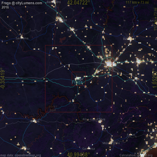
Analysis of Fraga night lights 2016
Square area 10x10 km:
100  2.04%
2.04%
90-99 2.04%
80-89 3.23%
70-79 0.51%
60-69 0.34%
50-59 1.02%
40-49 0.34%
30-39 1.36%
20-29 2.72%
10-19 0.34%
0-9 86.05%
2.04%90-99
2.04%80-89
3.23%70-79
0.51%60-69
0.34%50-59
1.02%40-49
0.34%30-39
1.36%20-29
2.72%10-19
0.34%0-9
86.05%Square area 50x50 km:
100 0.45%
90-99 0.68%
80-89 0.96%
70-79 0.47%
60-69 0.68%
50-59 0.81%
40-49 0.48%
30-39 0.53%
20-29 1.52%
10-19 3.04%
0-9 90.37%
0.45%90-99
0.68%80-89
0.96%70-79
0.47%60-69
0.68%50-59
0.81%40-49
0.48%30-39
0.53%20-29
1.52%10-19
3.04%0-9
90.37%Clear (daylight) street map image can be seen on geolist.org.
Map coordinates:
42° 2' 50" North, 0° 21' 15.1" West
41° 31' 22.6" North, 0° 20' 56.2" East
40° 59' 39.8" North, 1° 3' 7.5" East
Some cities around Fraga sort by population:
• Lleida
25 km =15.5 mi,  65°
65°
• Monzón
45 km =28 mi,  343°
343°
• Mollerussa
47.4 km =29.5 mi,  75°
75°
• Binéfar
36.8 km =22.9 mi,  352°
352°
• Caspe
45.6 km =28.3 mi,  225°
225°
• Almacelles
24.4 km =15.2 mi,  17°
17°
• Alcarràs
14.8 km =9.2 mi, 70°
• Alpicat
23.4 km =14.5 mi,  47°
47°
3122157 (p: 14,302)
Sources (retrieved 2019-11-25):
» Earth at Night: Flat Maps 2012, 2016