Alcarràs night lights from space
Night Light of Alcarràs (Catalonia) from space (Spain) Src. Average luminocity for 10x10km area is 18.9082% and for 50x50km: 7.2429%.
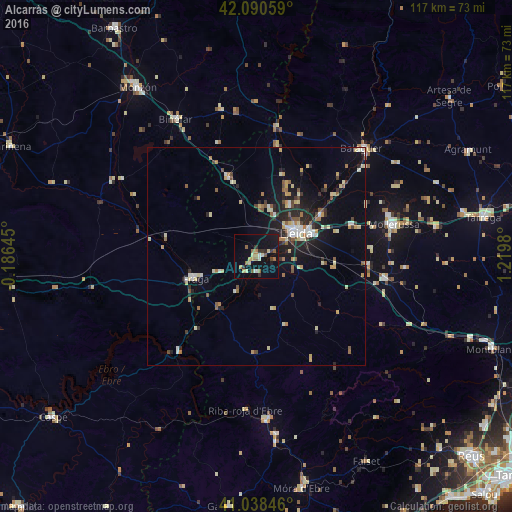
Analysis of Alcarràs night lights 2016
Square area 10x10 km:
 0.68%
0.68%90-99
1.53%80-89
4.25%70-79
1.53%60-69
4.08%50-59
3.57%40-49
0.68%30-39
2.89%20-29
1.87%10-19
20.92%0-9
57.99%Square area 50x50 km:
0.64%90-99
0.95%80-89
1.28%70-79
0.76%60-69
0.87%50-59
0.98%40-49
0.64%30-39
0.7%20-29
2.06%10-19
4.66%0-9
86.46%Clear (daylight) street map image can be seen on geolist.org.
Map coordinates:
42° 5' 26.1" North, 0° 11' 11.2" West
41° 34' 0" North, 0° 31' 0" East
41° 2' 18.5" North, 1° 13' 11.3" East
Some cities around Alcarràs sort by population:
• Lleida
10.4 km =6.5 mi,  57°
57°
• Monzón
46.7 km =29 mi,  325°
325°
• Balaguer
34.9 km =21.7 mi,  44°
44°
• Mollerussa
32.7 km =20.3 mi,  76°
76°
• Fraga
14.8 km =9.2 mi,  250°
250°
• Binéfar
36.6 km =22.7 mi, 329°
• Almacelles
19.5 km =12.1 mi,  340°
340°
• Alpicat
11.5 km =7.1 mi,  16°
16°
3130598 (p: 5,133)
Sources (retrieved 2019-11-25):
» Earth at Night: Flat Maps 2012, 2016