Corralejo night lights from space
Night Light of Corralejo (Canary Islands) from space (Spain) Src. Average luminocity for 10x10km area is 15.1799% and for 50x50km: 4.5216%.
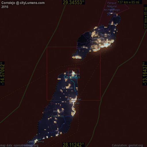
Analysis of Corralejo night lights 2016
Square area 10x10 km:
 1.33%
1.33%90-99
0.95%80-89
4.36%70-79
2.46%60-69
1.7%50-59
1.52%40-49
1.14%30-39
2.08%20-29
2.08%10-19
2.46%0-9
79.92%Square area 50x50 km:
0.25%90-99
0.46%80-89
0.63%70-79
0.92%60-69
0.49%50-59
0.58%40-49
0.85%30-39
0.76%20-29
0.71%10-19
2.2%0-9
92.16%Clear (daylight) street map image can be seen on geolist.org.
Map coordinates:
29° 20' 43.9" North, 14° 34' 14.2" West
28° 43' 50.8" North, 13° 52' 3" West
28° 6' 44.7" North, 13° 9' 51.7" West
Some cities around Corralejo sort by population:
• Puerto del Rosario
25.6 km =15.9 mi,  178°
178°
• Puerto del Carmen
29 km =18 mi,  42°
42°
• La Oliva
14.7 km =9.1 mi,  204°
204°
• Tías
33.5 km =20.8 mi, 40°
• San Bartolomé
38.9 km =24.2 mi, 39°
• Antigua
37.1 km =23.1 mi, 202°
• Playa Blanca
15.3 km =9.5 mi,  14°
14°
• Yaiza
27 km =16.8 mi,  21°
21°
2519217 (p: 13,618)
Sources (retrieved 2019-11-25):
» Earth at Night: Flat Maps 2012, 2016