Antigua night lights from space
Night Light of Antigua (Canary Islands) from space (Spain) Src. Average luminocity for 10x10km area is 10.2024% and for 50x50km: 4.5618%.
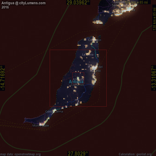
Analysis of Antigua night lights 2016
Square area 10x10 km:
 0%
0%90-99
0%80-89
2.58%70-79
2.18%60-69
1.59%50-59
0%40-49
2.98%30-39
2.18%20-29
3.97%10-19
0.79%0-9
83.73%Square area 50x50 km:
0.15%90-99
0.39%80-89
0.8%70-79
0.83%60-69
0.48%50-59
0.51%40-49
0.77%30-39
0.96%20-29
0.9%10-19
2.97%0-9
91.24%Clear (daylight) street map image can be seen on geolist.org.
Map coordinates:
29° 2' 22.6" North, 14° 43' 0.9" West
28° 25' 23.1" North, 14° 0' 49.6" West
27° 48' 10.4" North, 13° 18' 38.4" West
Some cities around Antigua sort by population:
• Puerto del Rosario
17.1 km =10.6 mi,  59°
59°
• La Oliva
22.4 km =13.9 mi,  21°
21°
• Pájara
12.2 km =7.6 mi,  228°
228°
• Tuineje
11.5 km =7.1 mi,  196°
196°
• Corralejo
37.1 km =23.1 mi, 22°
• Playa Blanca
52.3 km =32.5 mi, 20°
• Yaiza
64.1 km =39.8 mi, 22°
• Costa Calma
35.8 km =22.2 mi,  215°
215°
2521706 (p: 10,371)
Sources (retrieved 2019-11-25):
» Earth at Night: Flat Maps 2012, 2016