Coll d'en Rabassa night lights from space
Night Light of Coll d'en Rabassa (Balearic Islands) from space (Spain) Src. Average luminocity for 10x10km area is 62.0795% and for 50x50km: 12.5353%.
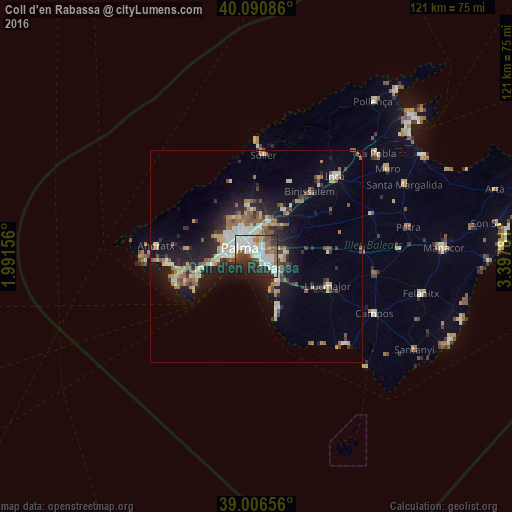
Analysis of Coll d'en Rabassa night lights 2016
Square area 10x10 km:
 22.56%
90-99
16.23%80-89
2.27%70-79
3.08%60-69
6.49%50-59
8.6%40-49
3.57%30-39
9.58%20-29
17.53%10-19
9.42%0-9
0.65%Square area 50x50 km:
1.95%90-99
2.03%80-89
1.52%70-79
1.16%60-69
1.68%50-59
2.1%40-49
1.22%30-39
1.77%20-29
3.46%10-19
8.44%0-9
74.66%Clear (daylight) street map image can be seen on geolist.org.
Map coordinates:
40° 5' 27.1" North, 1° 59' 29.6" East
39° 33' 3" North, 2° 41' 40.8" East
39° 0' 23.6" North, 3° 23' 52.1" East
Some cities around Coll d'en Rabassa sort by population:
• Palma
4.3 km =2.7 mi,  298°
298°
• Calvià
16.2 km =10.1 mi,  275°
275°
• Marratxí
8.3 km =5.2 mi,  18°
18°
• s'Arenal
7.4 km =4.6 mi,  139°
139°
• Es Molinar
2 km =1.2 mi,  305°
305°
• Palmanova
13.6 km =8.5 mi,  257°
257°
• Bunyola
16.2 km =10.1 mi,  1°
1°
• Can Pastilla
2.6 km =1.6 mi,  129°
129°
2519354 (p: 10,434)
Sources (retrieved 2019-11-25):
» Earth at Night: Flat Maps 2012, 2016