Begues night lights from space
Night Light of Begues (Catalonia) from space (Spain) Src. Average luminocity for 10x10km area is 36.0731% and for 50x50km: 40.0883%.
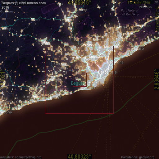
Analysis of Begues night lights 2016
Square area 10x10 km:
 0.34%
0.34%90-99
3.06%80-89
5.61%70-79
3.57%60-69
5.1%50-59
10.88%40-49
7.48%30-39
14.63%20-29
18.37%10-19
19.22%0-9
11.73%Square area 50x50 km:
10.07%90-99
8.94%80-89
4.06%70-79
4.66%60-69
6.59%50-59
5.04%40-49
2.79%30-39
3.89%20-29
10.29%10-19
13.06%0-9
30.61%Clear (daylight) street map image can be seen on geolist.org.
Map coordinates:
41° 51' 32.9" North, 1° 13' 48.8" East
41° 19' 60" North, 1° 55' 60" East
40° 48' 11.6" North, 2° 38' 11.3" East
Some cities around Begues sort by population:
• Sant Boi de Llobregat
8.7 km =5.4 mi,  82°
82°
• Viladecans
7.1 km =4.4 mi,  107°
107°
• Castelldefels
6.9 km =4.3 mi,  153°
153°
• Gavà
6.4 km =4 mi,  118°
118°
• Sant Vicenç dels Horts
9.1 km =5.7 mi,  42°
42°
• Vallirana
5.9 km =3.7 mi,  358°
358°
• Cervelló
7.3 km =4.5 mi,  17°
17°
• Santa Coloma de Cervelló
7.7 km =4.8 mi,  60°
60°
3128398 (p: 5,538)
Sources (retrieved 2019-11-25):
» Earth at Night: Flat Maps 2012, 2016