Arroyomolinos night lights from space
Night Light of Arroyomolinos (Madrid) from space (Spain) Src. Average luminocity for 10x10km area is 48.1981% and for 50x50km: 40.8103%.
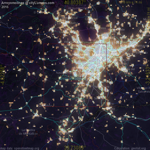
Analysis of Arroyomolinos night lights 2016
Square area 10x10 km:
 5.84%
5.84%90-99
9.25%80-89
4.87%70-79
1.79%60-69
9.25%50-59
12.99%40-49
9.58%30-39
10.88%20-29
19.32%10-19
15.26%0-9
0.97%Square area 50x50 km:
11.69%90-99
9.81%80-89
3.96%70-79
4.67%60-69
4.53%50-59
3.83%40-49
3.23%30-39
4.49%20-29
7.86%10-19
12.62%0-9
33.32%Clear (daylight) street map image can be seen on geolist.org.
Map coordinates:
40° 48' 13.9" North, 4° 37' 21.3" West
40° 16' 10.2" North, 3° 55' 10.1" West
39° 43' 51.2" North, 3° 12' 58.8" West
Some cities around Arroyomolinos sort by population:
• Móstoles
7.5 km =4.7 mi,  38°
38°
• Fuenlabrada
10.8 km =6.7 mi,  81°
81°
• Alcorcón
11.7 km =7.3 mi, 43°
• Villaviciosa de Odón
9.9 km =6.2 mi,  7°
7°
• Navalcarnero
8.1 km =5 mi,  285°
285°
• Humanes de Madrid
7.8 km =4.8 mi,  105°
105°
• Griñón
8.4 km =5.2 mi,  139°
139°
• El Álamo
7.7 km =4.8 mi,  235°
235°
3129356 (p: 13,835)
Sources (retrieved 2019-11-25):
» Earth at Night: Flat Maps 2012, 2016