Griñón night lights from space
Night Light of Griñón (Madrid) from space (Spain) Src. Average luminocity for 10x10km area is 49.4838% and for 50x50km: 38.7473%.
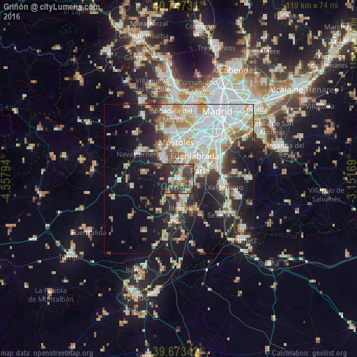
Analysis of Griñón night lights 2016
Square area 10x10 km:
 3.41%
3.41%90-99
8.28%80-89
5.03%70-79
5.03%60-69
8.93%50-59
8.77%40-49
13.64%30-39
25.49%20-29
17.86%10-19
3.57%0-9
0%Square area 50x50 km:
9.69%90-99
9.31%80-89
3.98%70-79
4.56%60-69
4.52%50-59
3.58%40-49
2.93%30-39
4.49%20-29
8.31%10-19
17.47%0-9
31.15%Clear (daylight) street map image can be seen on geolist.org.
Map coordinates:
40° 44' 50.3" North, 4° 33' 28.6" West
40° 12' 45" North, 3° 51' 17.4" West
39° 40' 24.3" North, 3° 9' 6.1" West
Some cities around Griñón sort by population:
• Móstoles
12.2 km =7.6 mi,  355°
355°
• Fuenlabrada
9.5 km =5.9 mi,  32°
32°
• Parla
7.9 km =4.9 mi,  70°
70°
• Illescas
10.1 km =6.3 mi,  176°
176°
• Humanes de Madrid
4.7 km =2.9 mi, 25°
• Arroyomolinos
8.4 km =5.2 mi,  319°
319°
• El Álamo
12 km =7.5 mi,  279°
279°
• Torrejón de la Calzada
5.1 km =3.2 mi,  107°
107°
3121105 (p: 7,484)
Sources (retrieved 2019-11-25):
» Earth at Night: Flat Maps 2012, 2016