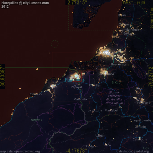
Huaquillas night lights from space
Night Light of Huaquillas (El Oro) from space (Ecuador) Src. Average luminocity for 10x10km area is 55.0952% and for 50x50km: 6.8692%.

Analysis of Huaquillas night lights 2016
Square area 10x10 km:
 9.09%
9.09%90-99
9.52%80-89
10.82%70-79
11.9%60-69
3.68%50-59
5.63%40-49
8.66%30-39
11.69%20-29
14.5%10-19
14.5%0-9
0%Square area 50x50 km:
0.67%90-99
0.68%80-89
1.35%70-79
0.87%60-69
0.34%50-59
0.68%40-49
1.12%30-39
1.5%20-29
1.97%10-19
5.7%0-9
85.12%Clear (daylight) street map image can be seen on geolist.org.
Map coordinates:
2° 46' 23.3" South, 80° 56' 2.3" West
3° 28' 30.8" South, 80° 13' 51" West
4° 10' 36.4" South, 79° 31' 39.8" West
Some cities around Huaquillas sort by population:
• Machala
38.5 km =23.9 mi,  51°
51°
• Tumbes, PE
26.5 km =16.5 mi,  247°
247°
• Pasaje
49.9 km =31 mi,  70°
70°
• Santa Rosa
30.3 km =18.8 mi,  84°
84°
• Zarumilla, PE
5.6 km =3.5 mi,  236°
236°
• Zorritos, PE
54.6 km =33.9 mi, 245°
• Aguas Verdes, PE
1.7 km =1.1 mi, 246°
• Puerto Bolívar
34.8 km =21.6 mi, 48°
3655720 (p: 39,757)
Sources (retrieved 2019-11-25):
» Earth at Night: Flat Maps 2012, 2016