Sánchez night lights from space
Night Light of Sánchez (Samaná) from space (Dominican Republic) Src. Average luminocity for 10x10km area is 3.1299% and for 50x50km: 0.9716%.
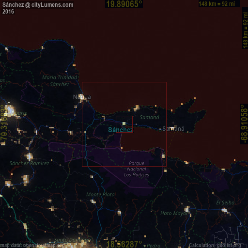
Analysis of Sánchez night lights 2016
Square area 10x10 km:
 0%
0%90-99
0%80-89
1.73%70-79
1.08%60-69
0.65%50-59
0%40-49
0%30-39
0%20-29
0%10-19
0%0-9
96.54%Square area 50x50 km:
0.01%90-99
0.08%80-89
0.14%70-79
0.15%60-69
0.31%50-59
0.14%40-49
0.13%30-39
0.23%20-29
0.14%10-19
0.16%0-9
98.5%Clear (daylight) street map image can be seen on geolist.org.
Map coordinates:
19° 53' 26.3" North, 70° 19' 0.6" West
19° 13' 41.2" North, 69° 36' 49.3" West
18° 33' 46.3" North, 68° 54' 38.1" West
Some cities around Sánchez sort by population:
• Nagua
30 km =18.6 mi,  305°
305°
• Sabana Grande de Boyá
36.7 km =22.8 mi,  210°
210°
• Sabana de la Mar
30.2 km =18.8 mi,  128°
128°
• Samaná
29.2 km =18.1 mi,  94°
94°
• Las Terrenas
11.8 km =7.3 mi,  38°
38°
• El Factor
30.5 km =19 mi,  289°
289°
• Villa Riva
31.9 km =19.8 mi,  260°
260°
• El Valle
37.4 km =23.2 mi,  138°
138°
3493198 (p: 11,365)
Sources (retrieved 2019-11-25):
» Earth at Night: Flat Maps 2012, 2016