Helsinge night lights from space
Night Light of Helsinge (Capital Region) from space (Denmark) Src. Average luminocity for 10x10km area is 1.8371% and for 50x50km: 6.4293%.
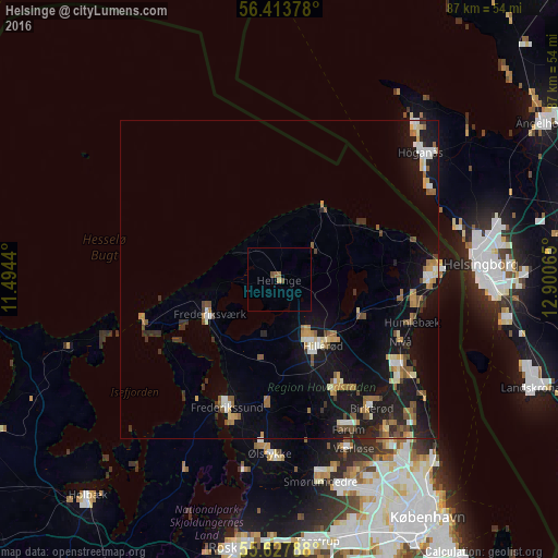
Analysis of Helsinge night lights 2016
Square area 10x10 km:
 0%
0%90-99
0%80-89
0%70-79
0.5%60-69
0%50-59
1.13%40-49
0.88%30-39
0%20-29
0%10-19
0%0-9
97.49%Square area 50x50 km:
0.52%90-99
0.85%80-89
0.64%70-79
0.7%60-69
1.09%50-59
1.1%40-49
0.87%30-39
0.8%20-29
1.05%10-19
7.11%0-9
85.28%Clear (daylight) street map image can be seen on geolist.org.
Map coordinates:
56° 24' 49.6" North, 11° 29' 39.8" East
56° 1' 22.2" North, 12° 11' 51.1" East
55° 37' 40.4" North, 12° 54' 2.3" East
Some cities around Helsinge sort by population:
• Hillerød
12.4 km =7.7 mi,  148°
148°
• Lillerød
18.9 km =11.7 mi, 150°
• Frederikssund
21.9 km =13.6 mi,  201°
201°
• Frederiksværk
12.3 km =7.6 mi,  241°
241°
• Fredensborg
13.8 km =8.6 mi,  112°
112°
• Nivå
21.5 km =13.4 mi,  117°
117°
• Slangerup
19.2 km =11.9 mi,  182°
182°
• Gilleleje
13.1 km =8.1 mi,  32°
32°
2620476 (p: 7,354)
Sources (retrieved 2019-11-25):
» Earth at Night: Flat Maps 2012, 2016