Gilleleje night lights from space
Night Light of Gilleleje (Capital Region) from space (Denmark) Src. Average luminocity for 10x10km area is 0.7823% and for 50x50km: 5.0869%.
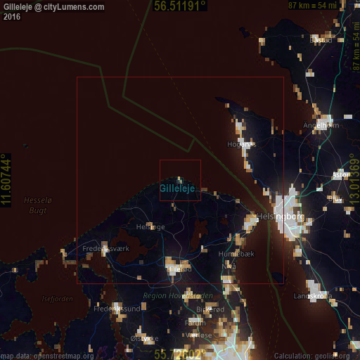
Analysis of Gilleleje night lights 2016
Square area 10x10 km:
 0%
0%90-99
0%80-89
0%70-79
0.48%60-69
0%50-59
0.24%40-49
0.24%30-39
0%20-29
0.48%10-19
0%0-9
98.56%Square area 50x50 km:
0.83%90-99
0.78%80-89
0.49%70-79
0.47%60-69
0.56%50-59
0.55%40-49
0.45%30-39
0.6%20-29
0.97%10-19
5.25%0-9
89.03%Clear (daylight) street map image can be seen on geolist.org.
Map coordinates:
56° 30' 42.9" North, 11° 36' 26.8" East
56° 7' 19.1" North, 12° 18' 38" East
55° 43' 40.9" North, 13° 0' 49.3" East
Some cities around Gilleleje sort by population:
• Helsingør
21.1 km =13.1 mi,  116°
116°
• Hillerød
21.6 km =13.4 mi,  181°
181°
• Höganäs, SE
17.6 km =10.9 mi,  60°
60°
• Espergærde
20.4 km =12.7 mi,  133°
133°
• Humlebæk
22.6 km =14 mi,  142°
142°
• Fredensborg
17.3 km =10.7 mi,  160°
160°
• Helsinge
13.1 km =8.1 mi,  212°
212°
• Hellebæk
16.5 km =10.3 mi,  111°
111°
2621471 (p: 5,799)
Sources (retrieved 2019-11-25):
» Earth at Night: Flat Maps 2012, 2016