Zwiesel night lights from space
Night Light of Zwiesel (Bavaria) from space (Germany) Src. Average luminocity for 10x10km area is 1.186% and for 50x50km: 0.8606%.
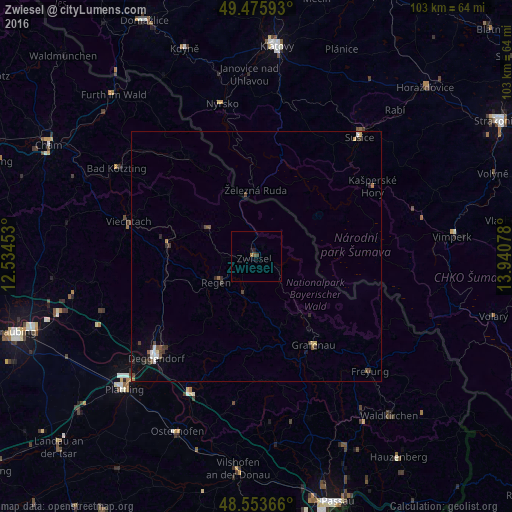
Analysis of Zwiesel night lights 2016
Square area 10x10 km:
 0%
0%90-99
0%80-89
0%70-79
0%60-69
0.6%50-59
0.6%40-49
0.15%30-39
0.45%20-29
0.15%10-19
1.04%0-9
97.02%Square area 50x50 km:
0.1%90-99
0.09%80-89
0.09%70-79
0.02%60-69
0.08%50-59
0.18%40-49
0.17%30-39
0.25%20-29
0.3%10-19
0.14%0-9
98.58%Clear (daylight) street map image can be seen on geolist.org.
Map coordinates:
49° 28' 33.3" North, 12° 32' 4.3" East
49° 1' 0.9" North, 13° 14' 15.5" East
48° 33' 13.2" North, 13° 56' 26.8" East
Some cities around Zwiesel sort by population:
• Deggendorf
28.2 km =17.5 mi,  225°
225°
• Regen
9.4 km =5.8 mi,  237°
237°
• Sušice, CZ
31.5 km =19.6 mi,  40°
40°
• Grafenau
21.2 km =13.2 mi,  146°
146°
• Viechtach
26.6 km =16.5 mi,  285°
285°
• Hengersberg
30.3 km =18.8 mi,  206°
206°
• Schöllnach
29.5 km =18.3 mi,  188°
188°
• Nýrsko, CZ
31.5 km =19.6 mi,  347°
347°
2803537 (p: 10,327)
Sources (retrieved 2019-11-25):
» Earth at Night: Flat Maps 2012, 2016