Wüstenrot night lights from space
Night Light of Wüstenrot (Baden-Württemberg) from space (Germany) Src. Average luminocity for 10x10km area is 0.1821% and for 50x50km: 11.2392%.
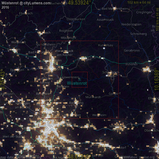
Analysis of Wüstenrot night lights 2016
Square area 10x10 km:
 0%
0%90-99
0%80-89
0%70-79
0%60-69
0%50-59
0%40-49
0%30-39
0.56%20-29
0%10-19
0%0-9
99.44%Square area 50x50 km:
1.42%90-99
1.62%80-89
1.1%70-79
1.13%60-69
1.57%50-59
1.61%40-49
1.84%30-39
2.16%20-29
3.09%10-19
8.5%0-9
75.97%Clear (daylight) street map image can be seen on geolist.org.
Map coordinates:
49° 32' 21.3" North, 8° 45' 26.7" East
49° 4' 51" North, 9° 27' 38" East
48° 37' 5.3" North, 10° 9' 49.3" East
Some cities around Wüstenrot sort by population:
• Bretzfeld
11.1 km =6.9 mi,  351°
351°
• Pfedelbach
11.3 km =7 mi,  16°
16°
• Aspach
13.4 km =8.3 mi,  199°
199°
• Oberstenfeld
11.9 km =7.4 mi,  239°
239°
• Untergruppenbach
13.5 km =8.4 mi,  274°
274°
• Beilstein
11.6 km =7.2 mi,  247°
247°
• Mainhardt
7 km =4.3 mi,  94°
94°
• Sulzbach an der Murr
9.1 km =5.7 mi,  161°
161°
2805497 (p: 6,770)
Sources (retrieved 2019-11-25):
» Earth at Night: Flat Maps 2012, 2016