Pfedelbach night lights from space
Night Light of Pfedelbach (Baden-Württemberg) from space (Germany) Src. Average luminocity for 10x10km area is 9.7213% and for 50x50km: 5.8067%.
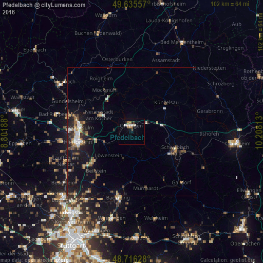
Analysis of Pfedelbach night lights 2016
Square area 10x10 km:
 1.82%
1.82%90-99
1.54%80-89
1.12%70-79
1.12%60-69
1.68%50-59
0.98%40-49
1.12%30-39
0.14%20-29
0.98%10-19
0.98%0-9
88.52%Square area 50x50 km:
0.71%90-99
0.66%80-89
0.53%70-79
0.51%60-69
0.65%50-59
1.08%40-49
0.97%30-39
0.92%20-29
1.76%10-19
4.58%0-9
87.64%Clear (daylight) street map image can be seen on geolist.org.
Map coordinates:
49° 38' 8.1" North, 8° 48' 6.8" East
49° 10' 41" North, 9° 30' 18" East
48° 42' 58.6" North, 10° 12' 29.3" East
Some cities around Pfedelbach sort by population:
• Öhringen
2.3 km =1.4 mi,  3°
3°
• Bretzfeld
4.8 km =3 mi,  271°
271°
• Neuenstadt am Kocher
14.1 km =8.8 mi,  296°
296°
• Wüstenrot
11.3 km =7 mi,  196°
196°
• Neuenstein
6.2 km =3.9 mi,  61°
61°
• Kupferzell
14.5 km =9 mi,  67°
67°
• Mainhardt
11.9 km =7.4 mi,  161°
161°
• Forchtenberg
12.9 km =8 mi,  18°
18°
2854152 (p: 8,879)
Sources (retrieved 2019-11-25):
» Earth at Night: Flat Maps 2012, 2016