Nierstein night lights from space
Night Light of Nierstein (Rheinland-Pfalz) from space (Germany) Src. Average luminocity for 10x10km area is 4.4505% and for 50x50km: 22.8558%.
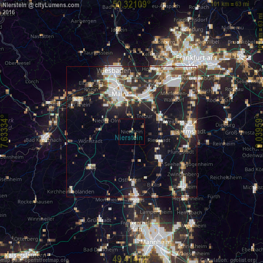
Analysis of Nierstein night lights 2016
Square area 10x10 km:
 0%
0%90-99
0%80-89
0.27%70-79
1.2%60-69
0.67%50-59
0.53%40-49
1.07%30-39
0.8%20-29
1.34%10-19
0.53%0-9
93.58%Square area 50x50 km:
4.64%90-99
4.89%80-89
1.71%70-79
1.95%60-69
2.34%50-59
2.28%40-49
3.03%30-39
3.53%20-29
7.39%10-19
15.67%0-9
52.56%Clear (daylight) street map image can be seen on geolist.org.
Map coordinates:
50° 19' 15.9" North, 7° 38' 0" East
49° 52' 12.1" North, 8° 20' 11.3" East
49° 24' 53" North, 9° 2' 22.5" East
Some cities around Nierstein sort by population:
• Groß-Gerau
11.9 km =7.4 mi,  61°
61°
• Ginsheim-Gustavsburg
11.3 km =7 mi,  3°
3°
• Trebur
8.1 km =5 mi,  38°
38°
• Nieder-Olm
10.5 km =6.5 mi,  296°
296°
• Bodenheim
7.4 km =4.6 mi,  350°
350°
• Oppenheim
2.4 km =1.5 mi,  135°
135°
• Stockstadt am Rhein
11.9 km =7.4 mi,  124°
124°
• Nackenheim
5 km =3.1 mi, 1°
2862485 (p: 7,729)
Sources (retrieved 2019-11-25):
» Earth at Night: Flat Maps 2012, 2016