Wörth am Rhein night lights from space
Night Light of Wörth am Rhein (Rheinland-Pfalz) from space (Germany) Src. Average luminocity for 10x10km area is 26.6146% and for 50x50km: 16.5519%.
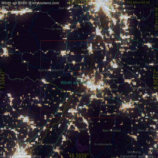
Analysis of Wörth am Rhein night lights 2016
Square area 10x10 km:
 4.46%
4.46%90-99
4.61%80-89
2.08%70-79
3.13%60-69
3.42%50-59
2.53%40-49
3.27%30-39
5.36%20-29
8.78%10-19
22.47%0-9
39.88%Square area 50x50 km:
2.01%90-99
2.52%80-89
1.52%70-79
1.72%60-69
1.82%50-59
2.19%40-49
2.51%30-39
2.59%20-29
3.96%10-19
16.72%0-9
62.43%Clear (daylight) street map image can be seen on geolist.org.
Map coordinates:
49° 30' 27.3" North, 7° 33' 23.3" East
49° 2' 56" North, 8° 15' 34.5" East
48° 35' 9.2" North, 8° 57' 45.8" East
Some cities around Wörth am Rhein sort by population:
• Karlsruhe
11.4 km =7.1 mi,  112°
112°
• Rheinstetten
9.6 km =6 mi,  158°
158°
• Eggenstein-Leopoldshafen
11.1 km =6.9 mi,  65°
65°
• Durmersheim
12.9 km =8 mi,  177°
177°
• Kandel
5.9 km =3.7 mi,  309°
309°
• Rülzheim
11.8 km =7.3 mi,  11°
11°
• Jockgrim
5 km =3.1 mi, 12°
• Hagenbach
3.6 km =2.2 mi,  190°
190°
2806081 (p: 17,272)
Sources (retrieved 2019-11-25):
» Earth at Night: Flat Maps 2012, 2016