Hagenbach night lights from space
Night Light of Hagenbach (Rheinland-Pfalz) from space (Germany) Src. Average luminocity for 10x10km area is 17.747% and for 50x50km: 16.58%.
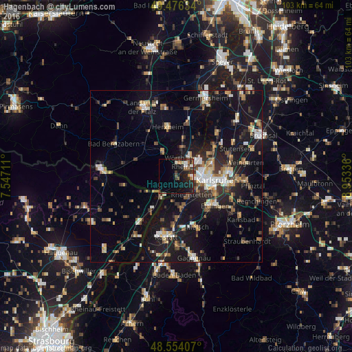
Analysis of Hagenbach night lights 2016
Square area 10x10 km:
 2.23%
2.23%90-99
2.53%80-89
0.89%70-79
2.08%60-69
2.23%50-59
1.79%40-49
2.08%30-39
2.98%20-29
6.99%10-19
19.35%0-9
56.85%Square area 50x50 km:
1.92%90-99
2.52%80-89
1.61%70-79
1.85%60-69
1.87%50-59
2.22%40-49
2.42%30-39
2.6%20-29
3.91%10-19
15.93%0-9
63.15%Clear (daylight) street map image can be seen on geolist.org.
Map coordinates:
49° 28' 34.8" North, 7° 32' 49.6" East
49° 1' 2.4" North, 8° 15' 0.9" East
48° 33' 14.7" North, 8° 57' 12.1" East
Some cities around Hagenbach sort by population:
• Karlsruhe
11.3 km =7 mi,  94°
94°
• Rheinstetten
6.8 km =4.2 mi,  142°
142°
• Wörth am Rhein
3.6 km =2.2 mi,  10°
10°
• Eggenstein-Leopoldshafen
13.5 km =8.4 mi,  53°
53°
• Durmersheim
9.4 km =5.8 mi,  172°
172°
• Kandel
8.2 km =5.1 mi,  332°
332°
• Jockgrim
8.6 km =5.3 mi, 11°
• Bietigheim
12 km =7.5 mi,  179°
179°
2912577 (p: 5,495)
Sources (retrieved 2019-11-25):
» Earth at Night: Flat Maps 2012, 2016