Rülzheim night lights from space
Night Light of Rülzheim (Rheinland-Pfalz) from space (Germany) Src. Average luminocity for 10x10km area is 8.409% and for 50x50km: 17.6709%.
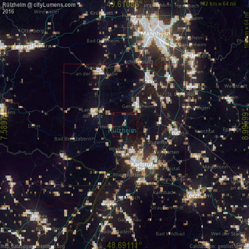
Analysis of Rülzheim night lights 2016
Square area 10x10 km:
 0%
0%90-99
0.56%80-89
0%70-79
0.42%60-69
1.54%50-59
0.28%40-49
3.5%30-39
2.24%20-29
0.7%10-19
3.5%0-9
87.25%Square area 50x50 km:
2.29%90-99
2.74%80-89
1.64%70-79
1.67%60-69
2.02%50-59
2.06%40-49
2.58%30-39
2.64%20-29
5.36%10-19
19.33%0-9
57.67%Clear (daylight) street map image can be seen on geolist.org.
Map coordinates:
49° 36' 39.1" North, 7° 35' 23.1" East
49° 9' 11.2" North, 8° 17' 34.3" East
48° 41' 28" North, 8° 59' 45.6" East
Some cities around Rülzheim sort by population:
• Germersheim
9.3 km =5.8 mi,  33°
33°
• Eggenstein-Leopoldshafen
10.4 km =6.5 mi,  132°
132°
• Linkenheim-Hochstetten
9 km =5.6 mi,  105°
105°
• Bellheim
5.1 km =3.2 mi,  349°
349°
• Kandel
10.5 km =6.5 mi,  221°
221°
• Jockgrim
6.8 km =4.2 mi,  191°
191°
• Offenbach an der Queich
8.4 km =5.2 mi,  304°
304°
• Lingenfeld
11.7 km =7.3 mi,  16°
16°
2843146 (p: 7,917)
Sources (retrieved 2019-11-25):
» Earth at Night: Flat Maps 2012, 2016