Wilthen night lights from space
Night Light of Wilthen (Saxony) from space (Germany) Src. Average luminocity for 10x10km area is 1.3128% and for 50x50km: 2.2393%.
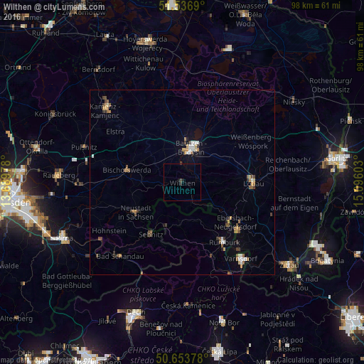
Analysis of Wilthen night lights 2016
Square area 10x10 km:
 0%
0%90-99
0%80-89
0%70-79
0%60-69
0%50-59
0%40-49
0.53%30-39
0.8%20-29
0%10-19
1.07%0-9
97.59%Square area 50x50 km:
0.18%90-99
0.34%80-89
0.13%70-79
0.36%60-69
0.36%50-59
0.4%40-49
0.38%30-39
0.35%20-29
0.2%10-19
0.59%0-9
96.71%Clear (daylight) street map image can be seen on geolist.org.
Map coordinates:
51° 32' 12.8" North, 13° 41' 23.2" East
51° 5' 50.8" North, 14° 23' 34.4" East
50° 39' 13.6" North, 15° 5' 45.7" East
Some cities around Wilthen sort by population:
• Bautzen
9.7 km =6 mi,  17°
17°
• Neustadt in Sachsen
14.4 km =8.9 mi,  237°
237°
• Bischofswerda
15.3 km =9.5 mi,  282°
282°
• Sebnitz
15.8 km =9.8 mi,  211°
211°
• Sohland
6.5 km =4 mi,  163°
163°
• Šluknov, CZ
11.2 km =7 mi, 158°
• Cunewalde
8.6 km =5.3 mi,  88°
88°
• Neukirch/Lausitz
5.9 km =3.7 mi,  269°
269°
2808406 (p: 6,304)
Sources (retrieved 2019-11-25):
» Earth at Night: Flat Maps 2012, 2016