Werther night lights from space
Night Light of Werther (North Rhine-Westphalia) from space (Germany) Src. Average luminocity for 10x10km area is 4.0847% and for 50x50km: 8.3214%.
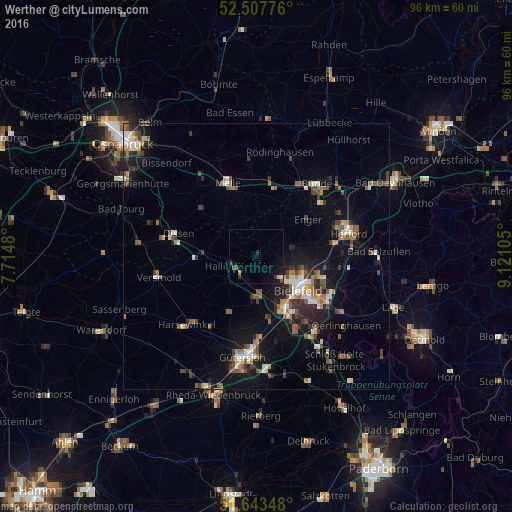
Analysis of Werther night lights 2016
Square area 10x10 km:
 0.26%
0.26%90-99
0.26%80-89
0.53%70-79
0%60-69
0.53%50-59
0.53%40-49
0.79%30-39
1.32%20-29
0.79%10-19
3.7%0-9
91.27%Square area 50x50 km:
0.84%90-99
1.22%80-89
0.7%70-79
0.63%60-69
1.22%50-59
1.43%40-49
1.65%30-39
1.19%20-29
2.06%10-19
6.23%0-9
82.83%Clear (daylight) street map image can be seen on geolist.org.
Map coordinates:
52° 30' 27.9" North, 7° 42' 53.3" East
52° 4' 39.8" North, 8° 25' 4.5" East
51° 38' 36.5" North, 9° 7' 15.8" East
Some cities around Werther sort by population:
• Bielefeld
9.3 km =5.8 mi,  122°
122°
• Melle
14.8 km =9.2 mi,  338°
338°
• Halle
4.4 km =2.7 mi,  243°
243°
• Steinhagen
8.7 km =5.4 mi,  188°
188°
• Enger
11.8 km =7.3 mi,  53°
53°
• Spenge
8.3 km =5.2 mi,  33°
33°
• Dissen
15.5 km =9.6 mi,  285°
285°
• Borgholzhausen
8.4 km =5.2 mi, 289°
2810710 (p: 11,575)
Sources (retrieved 2019-11-25):
» Earth at Night: Flat Maps 2012, 2016