Enger night lights from space
Night Light of Enger (North Rhine-Westphalia) from space (Germany) Src. Average luminocity for 10x10km area is 5.5833% and for 50x50km: 7.5694%.
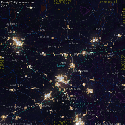
Analysis of Enger night lights 2016
Square area 10x10 km:
 0%
0%90-99
0.53%80-89
0.53%70-79
0.53%60-69
0%50-59
0%40-49
1.72%30-39
1.46%20-29
0.13%10-19
2.65%0-9
92.46%Square area 50x50 km:
0.7%90-99
1.01%80-89
0.72%70-79
0.76%60-69
1.05%50-59
1.27%40-49
1.49%30-39
1.03%20-29
1.67%10-19
5.39%0-9
84.9%Clear (daylight) street map image can be seen on geolist.org.
Map coordinates:
52° 34' 12.3" North, 7° 51' 16.6" East
52° 8' 26.3" North, 8° 33' 27.8" East
51° 42' 25.2" North, 9° 15' 39.1" East
Some cities around Enger sort by population:
• Bielefeld
12 km =7.5 mi,  187°
187°
• Herford
8.4 km =5.2 mi,  110°
110°
• Bünde
6.7 km =4.2 mi,  16°
16°
• Löhne
10.6 km =6.6 mi,  59°
59°
• Hiddenhausen
5 km =3.1 mi,  54°
54°
• Kirchlengern
8.4 km =5.2 mi,  37°
37°
• Spenge
5 km =3.1 mi,  269°
269°
• Werther
11.8 km =7.3 mi,  233°
233°
2930182 (p: 19,852)
Sources (retrieved 2019-11-25):
» Earth at Night: Flat Maps 2012, 2016