Velen night lights from space
Night Light of Velen (North Rhine-Westphalia) from space (Germany) Src. Average luminocity for 10x10km area is 0.5631% and for 50x50km: 4.8261%.
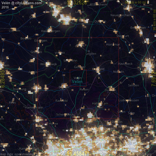
Analysis of Velen night lights 2016
Square area 10x10 km:
 0%
0%90-99
0%80-89
0%70-79
0%60-69
0.51%50-59
0%40-49
0%30-39
0%20-29
0.25%10-19
0.25%0-9
98.99%Square area 50x50 km:
0.34%90-99
0.66%80-89
0.26%70-79
0.48%60-69
0.89%50-59
0.98%40-49
0.82%30-39
0.72%20-29
0.57%10-19
2.65%0-9
91.63%Clear (daylight) street map image can be seen on geolist.org.
Map coordinates:
52° 19' 34.6" North, 6° 17' 5.8" East
51° 53' 40.1" North, 6° 59' 17.1" East
51° 27' 30.5" North, 7° 41' 28.3" East
Some cities around Velen sort by population:
• Borken
10.6 km =6.6 mi,  237°
237°
• Coesfeld
13.5 km =8.4 mi,  66°
66°
• Stadtlohn
12 km =7.5 mi,  336°
336°
• Gescher
6.7 km =4.2 mi,  9°
9°
• Klein Reken
12.5 km =7.8 mi,  162°
162°
• Raesfeld
17.1 km =10.6 mi,  213°
213°
• Südlohn
9.4 km =5.8 mi,  297°
297°
• Heiden
7.8 km =4.8 mi, 208°
2817704 (p: 13,074)
Sources (retrieved 2019-11-25):
» Earth at Night: Flat Maps 2012, 2016