Südlohn night lights from space
Night Light of Südlohn (North Rhine-Westphalia) from space (Germany) Src. Average luminocity for 10x10km area is 1.8788% and for 50x50km: 4.9927%.
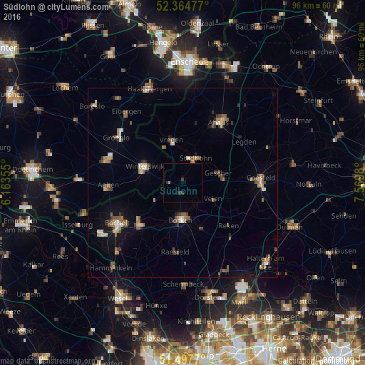
Analysis of Südlohn night lights 2016
Square area 10x10 km:
 0%
0%90-99
0%80-89
0%70-79
0.25%60-69
0.25%50-59
0%40-49
0.51%30-39
0.88%20-29
0.63%10-19
0.51%0-9
96.97%Square area 50x50 km:
0.32%90-99
0.67%80-89
0.39%70-79
0.59%60-69
0.85%50-59
0.97%40-49
0.8%30-39
0.63%20-29
0.45%10-19
1.99%0-9
92.32%Clear (daylight) street map image can be seen on geolist.org.
Map coordinates:
52° 21' 53.2" North, 6° 9' 48.8" East
51° 55' 60" North, 6° 52' 0" East
51° 29' 51.7" North, 7° 34' 11.3" East
Some cities around Südlohn sort by population:
• Borken
10 km =6.2 mi,  183°
183°
• Winterswijk, NL
11 km =6.8 mi,  293°
293°
• Vreden
11.9 km =7.4 mi,  347°
347°
• Stadtlohn
7.6 km =4.7 mi,  28°
28°
• Rhede
16 km =9.9 mi,  227°
227°
• Gescher
9.7 km =6 mi,  76°
76°
• Velen
9.4 km =5.8 mi,  117°
117°
• Heiden
12 km =7.5 mi,  157°
157°
2824998 (p: 9,024)
Sources (retrieved 2019-11-25):
» Earth at Night: Flat Maps 2012, 2016