Raesfeld night lights from space
Night Light of Raesfeld (North Rhine-Westphalia) from space (Germany) Src. Average luminocity for 10x10km area is 1.619% and for 50x50km: 13.6552%.
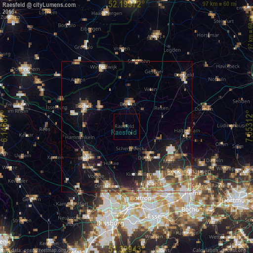
Analysis of Raesfeld night lights 2016
Square area 10x10 km:
 0%
0%90-99
0%80-89
0%70-79
0%60-69
0%50-59
0.56%40-49
1.54%30-39
0.14%20-29
0.56%10-19
0%0-9
97.2%Square area 50x50 km:
1.56%90-99
1.98%80-89
1.3%70-79
1.57%60-69
2.46%50-59
2.7%40-49
2.09%30-39
2.01%20-29
3.42%10-19
8.17%0-9
72.75%Clear (daylight) street map image can be seen on geolist.org.
Map coordinates:
52° 11' 59" North, 6° 8' 48.7" East
51° 46' 0" North, 6° 51' 0" East
51° 19' 45.9" North, 7° 33' 11.2" East
Some cities around Raesfeld sort by population:
• Dorsten
14.1 km =8.8 mi,  145°
145°
• Bocholt
18 km =11.2 mi,  296°
296°
• Borken
8.6 km =5.3 mi,  3°
3°
• Rhede
13.1 km =8.1 mi,  305°
305°
• Klein Reken
13.5 km =8.4 mi,  80°
80°
• Schermbeck
9.3 km =5.8 mi,  172°
172°
• Velen
17.1 km =10.6 mi,  33°
33°
• Heiden
9.4 km =5.8 mi,  37°
37°
2850942 (p: 11,218)
Sources (retrieved 2019-11-25):
» Earth at Night: Flat Maps 2012, 2016