Stockstadt am Rhein night lights from space
Night Light of Stockstadt am Rhein (Hesse) from space (Germany) Src. Average luminocity for 10x10km area is 16.0307% and for 50x50km: 18.7458%.
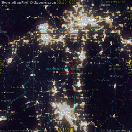
Analysis of Stockstadt am Rhein night lights 2016
Square area 10x10 km:
 3.34%
3.34%90-99
3.61%80-89
2.14%70-79
0.53%60-69
1.07%50-59
0%40-49
0%30-39
0.53%20-29
2.14%10-19
18.98%0-9
67.65%Square area 50x50 km:
3.2%90-99
3.55%80-89
1.59%70-79
1.65%60-69
1.85%50-59
1.65%40-49
2.13%30-39
2.66%20-29
6.9%10-19
18.17%0-9
56.63%Clear (daylight) street map image can be seen on geolist.org.
Map coordinates:
50° 15' 39.8" North, 7° 46' 10.8" East
49° 48' 34" North, 8° 28' 22" East
49° 21' 12.8" North, 9° 10' 33.3" East
Some cities around Stockstadt am Rhein sort by population:
• Griesheim
9.2 km =5.7 mi,  51°
51°
• Pfungstadt
9.4 km =5.8 mi,  92°
92°
• Riedstadt
3.2 km =2 mi,  31°
31°
• Büttelborn
11.1 km =6.9 mi,  19°
19°
• Gernsheim
6.4 km =4 mi,  169°
169°
• Oppenheim
9.5 km =5.9 mi,  301°
301°
• Biebesheim
3.2 km =2 mi,  187°
187°
• Bickenbach
11.8 km =7.3 mi,  118°
118°
2826671 (p: 5,741)
Sources (retrieved 2019-11-25):
» Earth at Night: Flat Maps 2012, 2016