Gernsheim night lights from space
Night Light of Gernsheim (Hesse) from space (Germany) Src. Average luminocity for 10x10km area is 13.8917% and for 50x50km: 15.6783%.
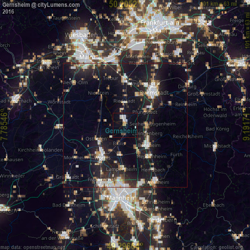
Analysis of Gernsheim night lights 2016
Square area 10x10 km:
 2.94%
2.94%90-99
2.94%80-89
0.53%70-79
0.94%60-69
1.2%50-59
0.53%40-49
1.6%30-39
0%20-29
0.53%10-19
10.96%0-9
77.81%Square area 50x50 km:
2.27%90-99
2.81%80-89
1.2%70-79
1.46%60-69
1.56%50-59
1.42%40-49
1.71%30-39
2.05%20-29
5.78%10-19
17.87%0-9
61.88%Clear (daylight) street map image can be seen on geolist.org.
Map coordinates:
50° 12' 18.7" North, 7° 47' 7.7" East
49° 45' 11" North, 8° 29' 18.9" East
49° 17' 47.9" North, 9° 11' 30.2" East
Some cities around Gernsheim sort by population:
• Riedstadt
9 km =5.6 mi,  3°
3°
• Alsbach-Hähnlein
7.9 km =4.9 mi,  101°
101°
• Biblis
7.2 km =4.5 mi,  197°
197°
• Zwingenberg
9.4 km =5.8 mi,  110°
110°
• Biebesheim
3.5 km =2.2 mi,  333°
333°
• Einhausen
9.5 km =5.9 mi,  153°
153°
• Stockstadt am Rhein
6.4 km =4 mi,  349°
349°
• Bickenbach
9.3 km =5.8 mi,  85°
85°
2920994 (p: 9,377)
Sources (retrieved 2019-11-25):
» Earth at Night: Flat Maps 2012, 2016