Sersheim night lights from space
Night Light of Sersheim (Baden-Württemberg) from space (Germany) Src. Average luminocity for 10x10km area is 17.9901% and for 50x50km: 24.1842%.
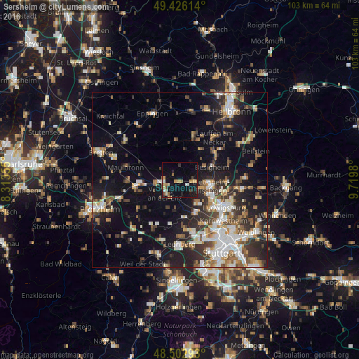
Analysis of Sersheim night lights 2016
Square area 10x10 km:
 1.7%
1.7%90-99
1.85%80-89
2.56%70-79
3.84%60-69
1.7%50-59
1.99%40-49
1.85%30-39
0.71%20-29
1.99%10-19
20.31%0-9
61.51%Square area 50x50 km:
3.94%90-99
4.49%80-89
2.11%70-79
2.6%60-69
3.22%50-59
2.97%40-49
3.3%30-39
3.74%20-29
6.66%10-19
15.72%0-9
51.27%Clear (daylight) street map image can be seen on geolist.org.
Map coordinates:
49° 25' 34.1" North, 8° 18' 48.8" East
48° 58' 0" North, 9° 1' 0" East
48° 30' 10.5" North, 9° 43' 11.3" East
Some cities around Sersheim sort by population:
• Bietigheim-Bissingen
7.8 km =4.8 mi,  108°
108°
• Vaihingen an der Enz
5.4 km =3.4 mi,  229°
229°
• Sachsenheim
3.6 km =2.2 mi,  101°
101°
• Markgröningen
8.3 km =5.2 mi,  145°
145°
• Tamm
8.9 km =5.5 mi,  125°
125°
• Besigheim
9.8 km =6.1 mi,  69°
69°
• Illingen
6.8 km =4.2 mi,  260°
260°
• Löchgau
7.7 km =4.8 mi,  57°
57°
2832939 (p: 5,199)
Sources (retrieved 2019-11-25):
» Earth at Night: Flat Maps 2012, 2016