Illingen night lights from space
Night Light of Illingen (Baden-Württemberg) from space (Germany) Src. Average luminocity for 10x10km area is 20.3267% and for 50x50km: 22.8551%.
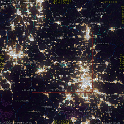
Analysis of Illingen night lights 2016
Square area 10x10 km:
 1.7%
1.7%90-99
3.41%80-89
1.99%70-79
1.99%60-69
3.41%50-59
2.98%40-49
3.69%30-39
1.56%20-29
0.28%10-19
21.16%0-9
57.81%Square area 50x50 km:
3.74%90-99
4.43%80-89
1.93%70-79
2.37%60-69
2.99%50-59
2.65%40-49
3.27%30-39
3.1%20-29
5.83%10-19
15.36%0-9
54.32%Clear (daylight) street map image can be seen on geolist.org.
Map coordinates:
49° 24' 56.6" North, 8° 13' 17.3" East
48° 57' 22.2" North, 8° 55' 28.5" East
48° 29' 32.4" North, 9° 37' 39.8" East
Some cities around Illingen sort by population:
• Vaihingen an der Enz
3.5 km =2.2 mi,  131°
131°
• Mühlacker
6.5 km =4 mi,  261°
261°
• Sachsenheim
10.2 km =6.3 mi,  87°
87°
• Niefern-Öschelbronn
11.2 km =7 mi,  246°
246°
• Maulbronn
10.1 km =6.3 mi,  298°
298°
• Eberdingen
9 km =5.6 mi,  160°
160°
• Wiernsheim
9.8 km =6.1 mi,  213°
213°
• Sersheim
6.8 km =4.2 mi,  80°
80°
2896539 (p: 7,205)
Sources (retrieved 2019-11-25):
» Earth at Night: Flat Maps 2012, 2016