Schwarzenberg night lights from space
Night Light of Schwarzenberg (Saxony) from space (Germany) Src. Average luminocity for 10x10km area is 8.7843% and for 50x50km: 3.9203%.
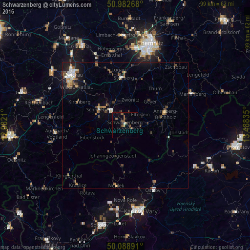
Analysis of Schwarzenberg night lights 2016
Square area 10x10 km:
 0.28%
0.28%90-99
0.28%80-89
0.56%70-79
0.84%60-69
3.08%50-59
2.66%40-49
1.26%30-39
0.56%20-29
1.68%10-19
1.12%0-9
87.68%Square area 50x50 km:
0.4%90-99
0.47%80-89
0.33%70-79
0.49%60-69
0.63%50-59
0.71%40-49
0.71%30-39
0.5%20-29
0.69%10-19
2.25%0-9
92.83%Clear (daylight) street map image can be seen on geolist.org.
Map coordinates:
50° 58' 57.6" North, 12° 4' 55.6" East
50° 32' 16.5" North, 12° 47' 6.8" East
50° 5' 20.1" North, 13° 29' 18.1" East
Some cities around Schwarzenberg sort by population:
• Aue
8.1 km =5 mi,  316°
316°
• Schneeberg
12 km =7.5 mi,  301°
301°
• Zwönitz
10.4 km =6.5 mi,  9°
9°
• Lößnitz
10.1 km =6.3 mi,  337°
337°
• Zschorlau
10.1 km =6.3 mi,  288°
288°
• Johanngeorgenstadt
12.8 km =8 mi,  204°
204°
• Bad Schlema
10.7 km =6.6 mi,  312°
312°
• Lauter
4.5 km =2.8 mi, 307°
2834978 (p: 18,523)
Sources (retrieved 2019-11-25):
» Earth at Night: Flat Maps 2012, 2016