Schwanau night lights from space
Night Light of Schwanau (Baden-Württemberg) from space (Germany) Src. Average luminocity for 10x10km area is 16.1037% and for 50x50km: 17.7442%.
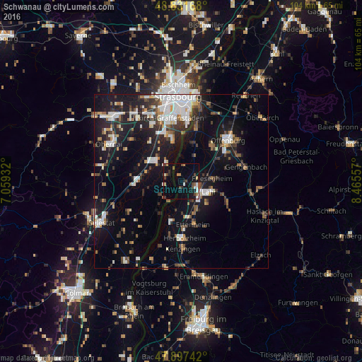
Analysis of Schwanau night lights 2016
Square area 10x10 km:
 2.27%
2.27%90-99
1.42%80-89
1.28%70-79
1.85%60-69
1.14%50-59
1.7%40-49
4.12%30-39
2.13%20-29
2.13%10-19
14.2%0-9
67.76%Square area 50x50 km:
3.61%90-99
3.23%80-89
1.06%70-79
1.37%60-69
1.95%50-59
1.79%40-49
2.1%30-39
2.79%20-29
4.49%10-19
14.76%0-9
62.84%Clear (daylight) street map image can be seen on geolist.org.
Map coordinates:
48° 49' 54" North, 7° 3' 33.6" East
48° 22' 0.1" North, 7° 45' 44.8" East
47° 53' 50.7" North, 8° 27' 56.1" East
Some cities around Schwanau sort by population:
• Lahr
8.4 km =5.2 mi,  110°
110°
• Ettenheim
12.7 km =7.9 mi,  163°
163°
• Erstein, FR
9.7 km =6 mi,  310°
310°
• Hohberg
11.3 km =7 mi,  115°
115°
• Schutterwald
12.9 km =8 mi,  43°
43°
• Seelbach
14.6 km =9.1 mi, 115°
• Benfeld, FR
12.5 km =7.8 mi,  272°
272°
• Kippenheim
9.2 km =5.7 mi,  149°
149°
7117230 (p: 6,858)
Sources (retrieved 2019-11-25):
» Earth at Night: Flat Maps 2012, 2016