Kippenheim night lights from space
Night Light of Kippenheim (Baden-Württemberg) from space (Germany) Src. Average luminocity for 10x10km area is 22.9315% and for 50x50km: 10.8998%.
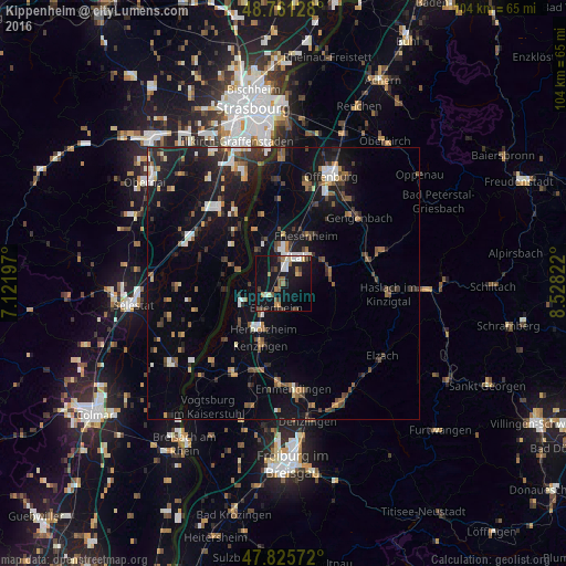
Analysis of Kippenheim night lights 2016
Square area 10x10 km:
 2.68%
2.68%90-99
2.83%80-89
2.23%70-79
0.74%60-69
5.06%50-59
3.27%40-49
2.53%30-39
3.57%20-29
2.68%10-19
38.84%0-9
35.57%Square area 50x50 km:
1.23%90-99
1.27%80-89
0.78%70-79
0.86%60-69
1.42%50-59
1.56%40-49
1.56%30-39
2.13%20-29
2.81%10-19
10.74%0-9
75.65%Clear (daylight) street map image can be seen on geolist.org.
Map coordinates:
48° 45' 40.6" North, 7° 7' 19.1" East
48° 17' 44.3" North, 7° 49' 30.4" East
47° 49' 32.6" North, 8° 31' 41.6" East
Some cities around Kippenheim sort by population:
• Lahr
5.9 km =3.7 mi,  33°
33°
• Ettenheim
4.4 km =2.7 mi,  192°
192°
• Herbolzheim
9.2 km =5.7 mi,  202°
202°
• Kenzingen
11.8 km =7.3 mi, 200°
• Hohberg
6.3 km =3.9 mi,  61°
61°
• Schutterwald
17.7 km =11 mi,  14°
14°
• Schwanau
9.2 km =5.7 mi,  329°
329°
• Seelbach
8.7 km =5.4 mi,  79°
79°
2890795 (p: 5,040)
Sources (retrieved 2019-11-25):
» Earth at Night: Flat Maps 2012, 2016